Mindanao Earthquake: Toll Rises to 106; Widespread Devastation in Southern Philippines
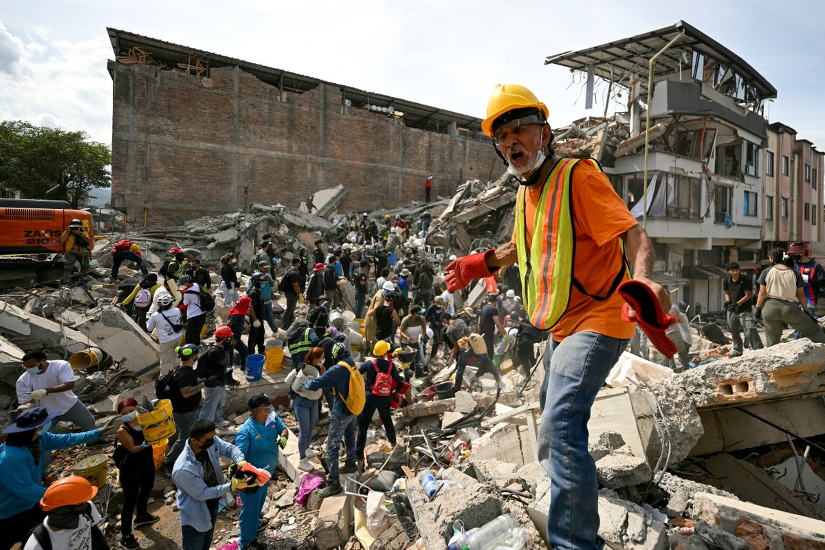
A powerful magnitude 7.8 earthquake struck off southern Mindanao, Philippines, on June 8, 2026, causing widespread destruction. The death toll rapidly rose, eventually reaching over 100, with thousands injured and displaced. Rescue efforts continue amid significant infrastructure damage.
Key Highlights
- 7.8 magnitude earthquake struck off Mindanao on June 8, 2026.
- Initial reports of death toll around 30-40, rising to over 100 later.
- Triggered tsunami warnings across several Pacific countries, later lifted.
- General Santos City and Sarangani province among the worst affected areas.
- Extensive damage to buildings, infrastructure, and triggered landslides.
- Thousands displaced, leading to outdoor hospitals and urgent relief efforts.
On June 8, 2026, a powerful magnitude 7.8 earthquake struck off the southern coast of Mindanao, Philippines, at approximately 7:37 a.m. Philippine Standard Time (23:37 GMT on June 7). The shallow earthquake, with a focal depth of around 10 to 33 kilometers, occurred about 20-32 kilometers southwest of Sarangani province. The seismic event triggered tsunami warnings across the southern Philippines, northern Indonesia, the Malaysian state of Sabah, and even prompted an advisory from Japan's meteorological agency; however, these warnings were later lifted.
Initial reports on June 8 indicated a death toll ranging from 15 to 35 people. Al Jazeera, in an article published on June 9, 2026, reported the death toll rising to at least 37, while The Hindu stated it had climbed to 41 on the same day. The casualties primarily resulted from collapsed buildings, falling debris, and landslides. General Santos City, a major coastal city with a population of about 720,000, bore the brunt of the destruction, experiencing significant building collapses and power outages. Sarangani province was also severely impacted, particularly in the mountainous town of Glan, where at least 13 people were buried in their homes by a landslide.
Rescue efforts immediately commenced, with teams racing to find survivors trapped under rubble. However, these operations were hampered by persistent aftershocks, which made conditions hazardous for rescuers. Hundreds of smaller tremors followed the main quake, adding to the anxiety of affected communities. The extensive damage to infrastructure, including roads and bridges, meant some areas became accessible only by helicopter, further slowing down aid distribution and rescue missions.
In the immediate aftermath, thousands were displaced from their homes, and more than 450 people were reported injured. Hospitals in affected regions, such as Glan, had to set up outdoor treatment areas, with patients being treated in tents due to concerns about the structural integrity of hospital buildings. Videos verified by AFP showed the catastrophic collapse of a shopping center in General Santos and an unoccupied school building crumbling. The earthquake struck on the first day back to school for many students, causing panic and trauma among schoolchildren. Philippine President Ferdinand Marcos Jr. ordered the cancellation of classes and activated emergency agencies, assuring that the national government would support Mindanao.
Over the subsequent days and weeks, the full extent of the devastation became clearer. By July 21, the death toll had tragically risen to at least 106 people, with 1,316 injured and 7 still reported missing across Mindanao. The worst-affected provinces included Sarangani (with 47 deaths), South Cotabato (24 deaths, including 22 in General Santos), and Davao Occidental (20 deaths). The earthquake was one of the most destructive in the Philippines in five decades, causing an estimated ₱71 billion (US$1.44 billion) in total damage. Over 138,500 homes were damaged or destroyed, along with numerous other buildings and facilities, particularly in towns like Sarangani, Jose Abad Santos, Glan, and Malapatan.
The Philippines, located on the seismically active 'Pacific Ring of Fire,' frequently experiences earthquakes and volcanic eruptions, making it one of the world's most disaster-prone countries. This event underscored the country's vulnerability to natural calamities and the ongoing challenges in preparing for and responding to such powerful seismic activities. International support was offered by allies like the United States, France, Japan, and New Zealand.
Frequently Asked Questions
When and where did the major earthquake in the Philippines occur?
A powerful magnitude 7.8 earthquake struck off the southern coast of Mindanao, Philippines, on June 8, 2026, at 7:37 a.m. local time.
What was the initial and final death toll from the Mindanao earthquake?
Initially, the death toll was reported around 15-35 on June 8, 2026, and rose to 37 by June 9, 2026, according to Al Jazeera. However, later reports by July 21 confirmed at least 106 fatalities, over 1,300 injuries, and 7 missing.
Which areas were most affected by the earthquake?
The most severely affected areas included General Santos City and Sarangani province, particularly the town of Glan, all located on the island of Mindanao.
Did the earthquake trigger a tsunami?
Yes, the earthquake triggered tsunami warnings for the southern Philippines, Indonesia, Malaysia, and Japan. While tsunami waves were observed, the warnings were subsequently lifted.
What kind of damage did the earthquake cause?
The earthquake caused extensive damage, including collapsed buildings, widespread power outages, landslides, and damaged infrastructure like roads and bridges. Thousands of homes were destroyed or damaged, leading to mass displacement.